
Walking Kaufman County Streets by Address
A street-by-street search works best as a record trail, not as a roster of people. First normalize the street and postal form with the USPS ZIP Code Lookup. Next, use the county mapping and appraisal records to establish the parcel behind that address. The resulting owner field and legal description lead to land records, while the map supplies jurisdiction and nearby parcel context. A name in a land record can identify an interest in property, but it does not establish that the named party lived there. Keep the result date beside every search because addresses, parcel labels, and ownership can change.
- Enter the street number and name in the Kaufman CAD property search. Save the property ID, geographic ID, situs address, legal description, and result date.
- Run the full address or PID in the Kaufman County GIS viewer. Check the parcel, jurisdiction, precinct, voting-location, school, ETJ, and flood layers that fit the question.
- Use the CAD owner name and legal description to search the County Clerk's recorded-index paths. Record party names, instrument type, recording date, and book, volume, page, or document reference.
- For a historical household lead, compare the dated address with telephone directories and newspaper images. Treat a listing or notice as a dated clue, not proof of continuous occupancy.
- When a current public election file is needed, ask Kaufman County Elections about the lawful field set, file date, and access procedure. Do not request or reproduce protected address or identifying fields.
That sequence keeps the Kaufman County street directory focused on records keyed to a place. It also avoids a common error: treating a map label, deed party, or postal match as evidence that a person currently occupies a building.
Kaufman County Street Directory CAD Fields
The Kaufman CAD search is the most direct county source for a parcel-led street directory search. Its address mode separates Street Number from Street Name, and its interface says to leave out a prefix, suffix, and unit number from the street-name field. The visible system also supports owner, property ID, and geographic ID searches. Use the address form first, then preserve both identifiers so that a later map or deed search does not depend on a street label alone. CAD describes its results as research and appraisal information, so legal descriptions and acreage need verification before they are relied upon.
| CAD field group | How it accepts a search | Useful address-record result |
|---|---|---|
| Street Number and Street Name | Text fields; street name excludes prefix, suffix, and unit | Finds the parcel tied to the normalized situs address |
| Owner Name and Owner ID | Text; the owner hint uses last name then first name | Offers a party lead for the recorded-index search |
| Property ID and Geographic ID | Text fields | Connects the appraisal result to GIS and a repeatable research note |
| Advanced land fields | Abstract, subdivision, condo, mobile-home park, and neighborhood controls | Helps distinguish similarly named streets or subdivisions |
| Property Type and Tax Year | Select controls in Advanced search | Sets the appraisal context for a particular result |
Save the displayed result heading, legal description, property type, tax year, neighborhood, subdivision, exemptions, map or PID link, and any last-updated text. Appraised values and exemptions are time-specific. They should not be carried backward as though they describe a past owner or resident.
Note: A property ID and geographic ID make a Kaufman County address search easier to reproduce after a street spelling changes.
Kaufman County Streets in GIS
The county GIS web map accepts a full address or PID. It is useful after CAD has identified a parcel because the viewer can place the address among parcels and show county precinct, neighborhood, school-district, voting-location, FEMA flood-zone, ETJ, and jurisdiction layers. Those layers help explain why an address may be associated with Kaufman, Forney, Terrell, Crandall, Kemp, Combine, or Mabank in different records. They do not turn a postal city or a parcel boundary into a current-residence finding.
For a block comparison, record adjacent parcel identifiers and the map date, not personal details about the people connected with them. Kaufman County says its GIS data are continuously maintained and updated and that accuracy is not guaranteed. The viewer is a relationship tool, not a certified survey, title record, or proof that someone occupies a structure. For a legal boundary question, compare the CAD legal description with a recorded instrument and ask the proper custodian when necessary.
Note: GIS layers help compare geography, but the county's accuracy warning means a result needs a source date and appropriate record check.
Kaufman County Street Record Routes
Different Kaufman County sources answer different address questions. CAD can provide an appraisal and parcel starting point. GIS adds geographic context. The County Clerk's index supplies recorded-instrument leads. Development Services handles certain unincorporated address records, while the county Elections office controls election materials and their field limits. This distinction matters because the same street can cross city, ETJ, precinct, or postal boundaries.
| Address-keyed source | Custodian | What it can show | Access channel |
|---|---|---|---|
| Property appraisal record | Kaufman CAD | Parcel identifiers, situs address, owner field, legal description, and appraisal context | Online search, CAD office, and its data or open-record channels |
| Parcel and jurisdiction map | County Development Services GIS | Address, PID, adjacent parcels, precinct, school, voting location, flood, ETJ, and jurisdiction layers | Online viewer; Development Services for existing address-point or map records |
| Recorded land instrument index | Kaufman County Clerk Real Property | Recorded party names, instrument details, and book, volume, page, or document references | Kofile index, Clerk counter, phone, email, e-fax, mail, or a narrow written request |
| E911 address material | Development Services / E911 Coordinator | Address-assignment and road or address-point context in covered areas | Application, written map request, phone, or PIA for existing records |
| Election records | Kaufman County Elections | Election or precinct materials and public fields where lawful | County route, inspection or request procedure, subject to confidentiality |
A commercial people-finder category may merge old data without showing its source date. Official records expose the custodian, field boundaries, and retrieval date. For a Kaufman County street directory inquiry, that makes it easier to verify a parcel fact and easier to stop when the available record cannot support a claim.
Kaufman County Street Deed Trails
The Kofile Kaufman deed index is the remote starting point for a recorded-land trail. Its Index Books search exposes Type, Year, Parties, Last Name, and First Name, while its document search uses Book, Volume, and Page. The visible index-book coverage is 1902 through 1968. Search both party directions and try initials, punctuation, married or maiden names, abbreviations, and spelling variants. A grantor may be an estate, lender, or trustee, so the party trail needs the instrument and legal description before it is linked back to a parcel.
The recorded-index interface is illustrated on the county-linked Kofile index.
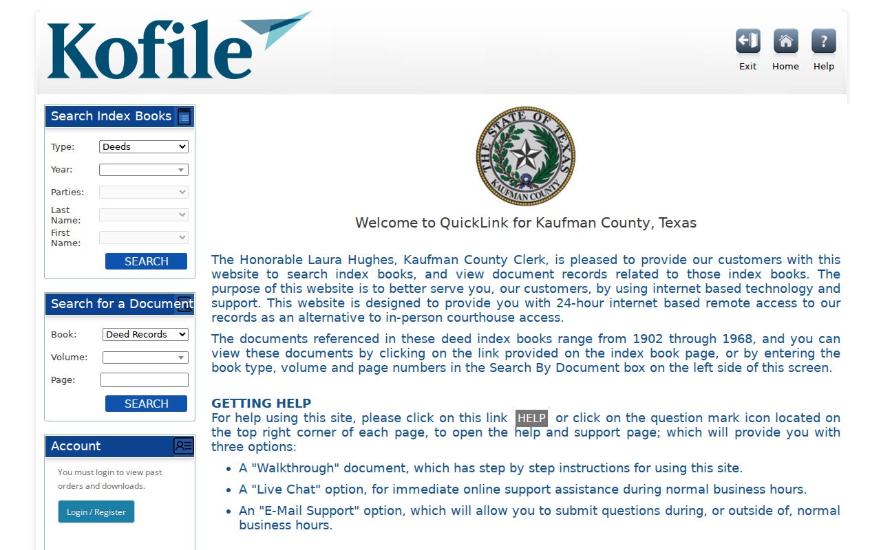
The image shows the two search paths that support a street-address trail once CAD supplies a party name or deed reference. It does not establish completeness of the county deed run or availability of every image.
If the online search misses a document, contact the Kaufman County Clerk, the authoritative and certified-copy fallback. Real Property / Vital Statistics is listed at 1902 E US Hwy 175, Kaufman, with 469-376-4730 and weekday hours of 8:00 a.m. to 4:30 p.m. Give the address or legal description, party variants, instrument type, recording range, and any book, volume, page, or document number. The Clerk can also direct an in-person, mail, e-fax, email, or written-request route.
Kaufman County Street Address Changes
An old address may need translation before any street directory search will line up. Kaufman County 911 Addressing describes E911 addresses for structures in unincorporated county and directs applicants to CAD and GIS maps. The standards say that addresses may be changed or reassigned for conformance. Record the former route, old street form, current normalized form, legal description, and the date attached to each source rather than assuming a familiar street label has always meant the same place.
The county's temporary construction-address notice, observed January 28, 2025, states that a temporary address expires after one year and that a final address is needed before occupancy or completion. It also states a $40 charge per address point. That notice is useful context for a change in an address trail, but it is not a resident list. Development Services maintains address points, roads, and boundary information; a written request can ask for an existing address-point or road-centerline document with a defined location and date range.
Note: An address reassignment can explain a mismatch between a deed, map, directory, and current postal string without proving who occupied the property.
Kaufman County Address Research Terms
Address research uses a few terms that look alike but serve different purposes. Keeping them separate prevents a property result from being treated as a person record.
- Parcel
- A defined piece of land used by CAD and GIS for appraisal and mapping. Its number is a useful research identifier, but it is not proof of occupancy.
- Situs address
- The physical property address shown in an appraisal record. It can differ from a mailing or postal label and may change over time.
- Plat
- A recorded map of a subdivision or surveyed tract that can help connect a lot and block to a legal description.
- Criss-cross directory
- An address-arranged directory. No verified Kaufman County run was located in the reviewed online sources, so confirm title, year, and access with a local institution.
Use the legal description and parcel identifiers to carry a street-directory lead from one source to another. A street name should remain a search aid, not the sole proof that two records concern the same place.
Kaufman County Street Voter Boundaries
Election geography can help route a Kaufman County address question, but it has strict limits. The county Elections page sends registration questions to VoteTexas resources, and the county GIS map can show a precinct or voting location. Texas voter guidance describes name, date of birth, and voter ID as public in the stated context, while Social Security numbers and Texas driver-license or PID numbers are confidential. Telephone numbers may not be copied, and some voter residence addresses receive protection.
Use a precinct only as a geographic clue. A vote-center notice or an election-result total cannot show that a named person lives on a street or cast a ballot. When historical or public election material is needed, request a specific existing file, election, precinct, date range, and lawful field set from Kaufman County Elections. Ask whether inspection, an electronic file, or a copy is available, and expect confidentiality rules to control the response.
Note: A protected voter address or telephone field cannot be inferred from a precinct, a map label, or an older public election document.
Kaufman County Street Directory Limits
No single record proves a present household. CAD can identify a parcel and display an owner field. A deed can document a recorded interest. GIS can place an address within layers that are maintained but not guaranteed accurate. A telephone directory, obituary, or newspaper notice can offer a dated historical lead. Each is valuable for its own purpose, but none should be expanded into a compiled list of current residents. Use at least two independent, lawful signals before treating records as the same person, and preserve the source date and why the match was made.
Protected voter information, substitute addresses, private contact details, and vulnerable-person data do not belong in a street directory. For safety concerns, use the appropriate official confidentiality or victim-service route instead of trying to resolve a person through address records.
Kaufman County Street Record Requests
When an online record is incomplete, the Texas Public Information Act is a written-request route for existing government documents. It is not a request for staff to identify everyone on a street or create a new address list. The Texas Attorney General request guidance recommends naming the governmental body, record category, exact address or PID, date range, preferred format, and a willingness to receive a cost estimate. For deeds, the County Clerk is the first recipient. For an address point, map, permit, or 911 file, direct a bounded request to Development Services.
Ask for the non-confidential portion of a record and avoid sending sensitive identifiers. A request for an existing parcel record, map layer, or instrument range is clear and reproducible. A broad request for all information about a person or all residents on a street is not. If a custodian refers the matter elsewhere, use the named office rather than assuming that CAD, GIS, and Clerk records share the same retention or access rules.